I have a confession. I am a speed-oholic. Regardless of whether I am in a hurry to get someplace or not, I almost always drive 5 miles per hour over the speed limit. I can’t help it, I’m compelled to speed by some inner character flaw.
The thing is, I’m not the only one. Despite my speeding, I routinely get passed by other apparent speed-oholics who drive even faster than I do! During rush hour, I would bet that the average speed on many streets is well above the posted speed limit unless congestion forces people to drive more slowly. In a recent survey, 87 percent of drivers admitted to speeding at least occasionally, although 35 percent say it is never acceptable (hmm . . .). [1]
According to the National Highway Traffic Safety Administration, speeding was a contributing factor in 29 percent of all crashes that resulted in at least one fatality. [2] And it is probably safe to assume that speeding contributes to a similar percentage of the 5 million or so accidents that occur each year and the $12 billion that is paid annually in auto insurance payouts. So if the consequences of speeding are so well documented, why is the problem so pervasive?
Tragedies Galore
In my previous post, I focused on the ‘tragedy’ of congestion that never goes away despite the billions of dollars that are spent annually on road widening and other improvements. I used the economic theory behind the ‘tragedy of the commons’ and the practical dynamics of Marchetti’s Constant to shed some light on this phenomenon. In this post, I’m going to detail several other tragedies behind the way we design and utilize our streets and highways.
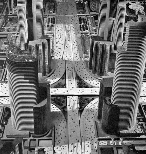
To start with, let’s get back to the speeding issue because there is more to it than just a character flaw. We have designed our cities and road networks so that speeding is almost inevitable. Keep in mind that a large percentage of the population believes in the American Dream – owning a single-family home on a large lot well away from the noise and nuisances of commercial and industrial properties. In short, our own little slice of Frank Lloyd Wright’s Broadacre City.

Unfortunately, extending this dream to millions of households means building square mile after square mile of residential subdivisions containing virtually nothing other than single-family homes. While each home is indeed a quiet refuge from hectic urban life, this layout guarantees that every other aspect of our life requires a trip to a place that is now quite distant from our home. Sure, some of us might be just a block or two from the supermarket, but for most of us it is a mile or more. The same is true for our favorite coffee shop, our kids’ school, the dentist’s office, the dry cleaners, and on and on. A major component of suburban life is now defined by the time we spend in our cars going from place to place. Since the distances are largely fixed, the only variable in our control is how fast we drive.
No wonder we are tempted to drive 40 (or 45) when the speed limit is 35. Not only that, but we press our elected officials for street improvements that let us drive even faster. For decades, we have encouraged our Public Works Departments and civil engineers to make streets straighter, flatter, and wider – ostensibly in the name of accident reduction but mainly so that we feel safe driving faster. They have added medians, turn lanes, coordinated traffic signals, and better lighting all in the pursuit of traffic safety and capacity. And yet despite all of these “improvements,” traffic accidents, injuries and fatalities remain stubbornly high.
The problem is closely related to the previously discussed issue of traffic congestion. Yes, replacing a winding, narrow 2-lane road with a straight, 4-lane divided street will probably reduce side-swipes or cars sliding into the ditch. But along with that reduction in minor accidents will come a change in the behavior of the people driving that street. The perceived increase in safety will cause them to drive faster (whether the speed limit is raised or not) and the increase in capacity will cause an increase in traffic volume. This increase in speed and volume means that the accidents which do occur will now be significantly more severe. Hence, we haven’t really solved the problem, we have simply changed the nature of the problem (probably for the worse).
Squeezing Out the Alternatives
Our current process of street improvements leads to another problem which is less obvious but equally damaging. For a variety of reasons that I have covered in previous posts, our cities work better when people have multiple modes of transportation available to them. Street rights-of-way are perfectly capable of not only accommodating cars, but also people who are walking, biking, taking transit or riding a scooter. As traffic volumes and speeds increase, however, all of the other forms of transportation become less attractive. Who wants to walk across six lanes of traffic or bike on a street where cars are zooming past at 45 miles per hour? It isn’t safe and it isn’t enjoyable.
The result is that in many places, the car is the only viable option for transportation. Yes, people walk their dogs or ride their bikes for exercise, but they rarely venture out of their subdivisions unless they are on a bike/hike trail that is separate from the street. Moreover, this type of transportation tragedy is self-reinforcing. The less common alternative forms of transportation become, the more engineers focus on maximizing vehicular throughput. Adding pedestrian crosswalks, bike lanes or even bus stops is often seen as a negative because they are viewed as an impediment to smooth traffic flow.
Several years ago, I attended a conference in downtown Dallas. My hotel was four or five blocks from the location of the conference sessions and while it was not a difficult walk, I noticed that Dallas had a dockless, e-scooter sharing system throughout the downtown. I downloaded the app and gave it a try. It was exhilarating and much faster than walking. But there was a problem. If I rode on the sidewalk, I scared the bejesus out of pedestrians as I went by – even though I was careful to give them a wide berth. If I rode in the street, I felt I had to take an entire lane of traffic in order for me to feel safe but then I was a major traffic obstruction. In short, downtown Dallas was so focused on vehicular traffic that there was no place for a perfectly good form of transportation.
Lipstick on a Pig
When was the last time you heard someone say “Wow, I really like the way the design of this freeway has been integrated into the character of the neighborhood”? I’m going to guess “Never” because for most traffic engineers aesthetics is so low on their priority list that it rarely is taken seriously. The fact of the matter is that most urban arterials and highways are a blight that cities must endure rather than an enhancement to a neighborhood’s visual attractiveness.
Another thing you never hear anyone say is “Wow, this is a lovely parking lot, let’s hang out here a little bit longer.” Although technically not part of the public right-of-way, parking lots are the universal appendage to city streets and most of them are equally ugly. Our addiction to traveling by car has led to an equal obsession with finding convenient parking – “convenient” meaning obvious in its location and so abundant that empty spaces are always available. The result is that parking lots are not only visually prominent, but we dedicate a huge percentage of our cities to this unattractive and relatively low-value use. I checked the percentage of the urban core that is devoted to parking for five midwestern cities (Indianapolis, Kansas City, Minneapolis, Omaha and Wichita) and the average was just over 25 percent. [3] And this is for the urban core where land values should be highest (suburban commercial areas would be much worse).
This need not be the case. Some streets are designed to be aesthetically pleasing and to blend nicely with the surrounding area. My hometown of Kansas City is known for its system of boulevards lined with beautiful trees. Not that most Kansas Citians would notice since they are more concerned with speeding up to get through that next traffic light (the boulevards are also unnecessarily wide which encourages speeding). When traffic throughput is your primary concern, the visual quality of the place that the street is passing through is going to be shortchanged. Hence, this is next in our list of ‘tragedies.’ Instead of our major streets and highways being an attractive gateway to our neighborhoods and business centers, they are an ugly gash which divides instead of unites and which we endure instead of enjoy.
This problem was especially prevalent during the early decades of freeway expansion when limited access highways were extended into the downtown core to meet the needs of suburban commuters. These roadways were frequently routed through poor neighborhoods which lacked powerful political voices and where land acquisition costs were low. The result is that neighborhoods that often functioned well (even if the buildings were not pristine) were split in half by six, or eight, or ten lanes of concrete. The one-two punch of an interstate highway followed by urban renewal projects such as Cabrini-Green in Chicago or Pruitt-Igoe in St Louis destroyed many inner city neighborhoods and fostered decades of social unrest.
Asset or Liability
Finally, there is the economic impact of our current approach to street and highway design. In theory, a street is a public asset that adds value to all of the abutting property. This value can be captured by the city through property taxes. The problem is that this asset comes with an attached liability – the implicit promise by the city to maintain that street or highway forever. Ideally, that maintenance cost is more than covered by property tax revenue, but that is increasingly not the case.


Our Broadacre City/Futurama approach to urban growth has changed the value proposition of streets. In short, there is too little value to balance the long-term cost of maintenance. Look, for example, at the three commercial properties shown above. Two are older commercial buildings common in the central portions of many cities, while the third is an example of “big box” development common in newer suburban areas. All three properties include off-street parking, but only the big box example provides a parking lot that is larger than the building itself. The appraised value per square foot of lot area is $90 for the first example, $58 for the second example, and $17 for the third.
Thus, the final tragedy is that our sprawling suburban street pattern is generating so little property tax revenue that we are putting our cities in a precarious financial position. Instead of supporting urban resilience, we are promoting fragility. Every unexpected event that stresses the municipal budget puts a city at risk of economic failure unless it receives some type of bailout from the state or federal government. No wonder that some cities seem to careen from one crisis to the next and local tax rates continue to climb.
Solutions
We have allowed the transportation pendulum to swing so far toward the automobile that we have lost the balance that cities and people need. I like my car and I use it on a regular basis, but I have found that I am healthier, happier and more connected to my community when I occasionally get out of my two-ton, steel bubble. The focus of our cities should be on the well-being and prosperity of our citizens, and the focus of our transportation system should be on supporting that well-being and prosperity by allowing people to move efficiently.
The modern ‘tragedy of the commons’ is that we have allowed the metric for how we design our streets to be shifted from moving people efficiently in support of their well-being to simply moving vehicles efficiently. Those two objectives are not at all the same. The result is a public street system that is often congested, dangerous, ugly and expensive.
Over the next several paragraphs I’m going to suggest several steps that could be taken to swing the transportation pendulum back toward some semblance of balance. There are, however, two caveats. First, I’m going to focus on midwestern cities. The east- and west-coast mega cities have problems that are so different in scale that different approaches are needed. Second, I’m not at all confident that the solutions I’m going to suggest will ever be implemented widely enough to have much of an effect. This is odd to write because all of my suggestions are being done now in cities across the country – they just aren’t being done frequently enough to have a significant impact. The car oriented lifestyle has simply become too ingrained in our American psyche. We routinely opt for the easy (and often logical) option of the car even if our short-term convenience is, in the aggregate, bad for us and bad for our community. Still, even baby steps move us in the right direction and might someday surprise me with their additive effect.
Shorter trips. If we can shorten the typical trip length, we would reduce vehicular congestion, increase the usage of alternative forms of transportation, and would probably reduce our inclination to speed. The first step is to increase the diversity of uses within each neighborhood. Large swaths of single-purpose land uses, whether they be residential, retail or office, are a bad idea. The planning profession promoted that approach in the past because it minimized conflicts between adjacent uses, but it has a horrible impact on urban life.
The second step is to increase density in selective areas. Each metro area should have dozens of moderate-density, mixed use nodes (mini-downtowns, if you will). People who live in or near each node will have a variety of destinations that they can reach quickly using a variety of transportation options. The vast majority of people will still live some distance away in low-density residential areas, but even they will have a decent chance of finding what they need in the closest node rather than driving to a singular downtown or a regional shopping center. Not every trip needs to be short, we just need more trips to be short.
Spread out vehicular demand. Virtually every midwestern city already has plenty of vehicular capacity, except for selective locations at certain times of the day. Instead of focusing on increasing capacity (supply), we should spend more time on reducing demand. The COVID pandemic provided an excellent illustration of this approach because traffic volume in the first few months dropped by 20 to 30 percent and congestion evaporated. The shift to hybrid work has the potential to extend that reduction in demand and cities should do what they can to encourage employers to adopt that policy.
Even employers that can't do remote or hybrid scheduling can time-shift their work hours by 30 or 60 minutes (or more) to reduce peak hour demand. Some employers already do this, of course, including some that have different start times for different groups of employees. This can enable a midwestern company in the central time zone to have some employees work from 7AM to 4PM, and others from 10AM to 7PM thus enabling a human response to customer inquiries from 8AM eastern time to 5PM pacific time. Although techniques like time shifting and hybrid work will cause managers to have to rethink scheduling and resource allocation, it is not that hard to do with modern technology. It may be that in-person meetings are concentrated between 10AM and 3PM or on certain days of the week when the majority of people should be in the office. This might seem problematic at first but could end up being a blessing in disguise for those who dread endless meetings.
Unfortunately, this solution will be of just limited effectiveness for two primary reasons. First, cities have very little direct control over the hours that people are expected to work. Cities can suggest and perhaps cajole, but rarely can require changes to work schedules. Second, a reduction in peak demand that leads to less congestion will simply cause some people to shift their travel habits away from transit or car-pooling to the automobile since travel times are suddenly improved. This is what happened a few months into the pandemic so that while traffic volumes did decline somewhat, transit volumes declined even more.
Rethink parking. Our insistence on using cars for nearly every trip we make has led to an almost equivalent obsession with parking. Not surprisingly, public parking is another classic ‘tragedy of the commons’ type of problem. Providing free public parking in areas of high demand without any restrictions invariably leads to skewed behavior. During my career as a city planner, I worked with several cities on revitalizing their historic downtowns. Parking was always an issue, particularly on-street parking on the primary shopping street. All of the downtown stakeholders would agree that shop owners and employees should voluntarily park a couple of blocks away so that the best spaces would be available for customers. Yet when we actually observed parking behavior, a large percentage of the spaces would be occupied for long periods of time by shop owners and their employees. Everyone wanted someone else to be the one to sacrifice for the common good.
The most common solution to this perceived problem is to provide public off-street parking lots, sometimes at the expense of existing buildings. This leads to a downward spiral aptly described by Andres Duany (et al) as follows:
. . . at mid-century, with automobile ownership on the rise, a charming old downtown with a wonderful pedestrian realm finds itself in need of more parking spaces. It tears down a few historic buildings and replaces them with surface parking lots, making the downtown both easier to park in and less pleasant to walk through. As more people drive, it tears down a few more buildings, with the same result. Eventually, what remains of the old downtown becomes unpleasant enough to undermine the desire to visit, and the demand for parking is easily satisfied by the supply. [4]
In other words, the disease is eliminated by killing the patient.
Planners have attempted to address the shortage of public parking by requiring developers to provide private, off-street parking every time they build a new building. Unfortunately, the only parameters that planners typically know during the development process are the size of the building and the general use of the building (i.e. retail, office, hotel, etc.). Despite considerable research on the subject, it turns out that those two factors are poor predictors of parking demand. Planners pressed on, however, and developed minimum parking standards that are now part of nearly every zoning code.
The fact that building size is a poor predictor of parking demand, and that most parking standards are biased toward meeting peak demand instead of average demand, means that development over the past several decades has been massively oversupplied with parking. [5] Go to a shopping center or office park on a typical day and you will often find the parking lot only half full. The problem, of course, is that all of this “free parking” isn’t really free. The cost of parking is included in the price we pay for every good and service that we buy. Even people who walk or take the bus to the shopping center pay the same hidden parking fee. This means that non-drivers (largely poor people) help subsidize the cost of free parking for drivers (largely affluent people).
The oversupply of parking results in retail buildings surrounded by enormous parking lots which means everything is further spread out which, in turn, lengthens every trip that we take. People often drive to the shopping center to shop at Store A, and then get back in their car to drive across the parking lot to shop at Store B in the same shopping center. Walking is no longer a viable option.
Cities should consider two significant changes to the way parking is handled. First, zoning codes should be amended to substantially reduce the amount of off-street parking required by new development. Some cities have eliminated parking requirements all together which might be a step too far, but major reductions are a good first step. Second, public parking in areas of high parking demand should always have an explicit cost. Parking meters and self-pay systems have gotten so sophisticated (including dynamic pricing) and phone-based payment capabilities so ubiquitous that paying for parking isn’t even much of a hassle anymore. The result will be parking that is easier to find and streets that are less congested. The icing on the cake is that underutilized parking lots will be converted to much more productive uses which will increase property tax revenues.
Modify street design criteria. Engineers design streets to meet the criteria given by the community. In a society dominated by cars, the criteria have been dominated by concerns over traffic capacity and speed. To swing the pendulum back toward a more balanced transportation system, we need those criteria to include a pleasant pedestrian environment and a safe cycling environment. Not only is this possible, there is already a movement known as “complete streets” that is gathering momentum across the country. Traffic lanes are being narrowed and reduced in number, bike lanes are being added, sidewalks are being widened, and crosswalks are being enhanced with bumped-out curbs. Traffic throughput is still a consideration, it is just not the only consideration.
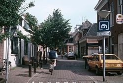 |
| A Woonerf |
While a shift toward “complete streets” design criteria is long overdue, it should be pointed out that not every street need be a biker’s or walker’s paradise. Some streets should probably retain a focus on moving vehicles as efficiently as possible, but those streets are far fewer in number than most people would expect. At the other end of the spectrum, cities should consider converting some residential streets to what is known as a Woonerf design which emphasizes pedestrian activity and extensive landscaping over everything else. Originally a Dutch planning concept, a Woonerf generally has no firm delineation between the sidewalk and the street. Pedestrians are allowed everywhere, including using the street as a social area for adults or a play area for children. Cars are allowed but they must defer to pedestrians and speed limits are very low.
Summary
Can we save our streets and highways from the various ‘tragedies’ from which they currently suffer? I think we should definitely try but I think the odds of success are low. The ideal that we all secretly covet – being able to jump in our car and drive quickly and easily to any location – is too ingrained for us to give up regardless of how far short reality falls from the ideal. We have shaped not only our streets but also our cities to try to achieve this utopian dream, only to fail repeatedly. Perhaps at some point we will realize that the car is not a one-size-fits-all transportation savior – but we aren’t there yet. I fear the best we can hope for are small victories that point the way toward what is possible if we take the commons back from the automobile.
Notes:
1. Susan Meyer; “Study: 9 in 10 drivers admit to speeding even though a third say it’s unacceptable”; TheZebra; September, 2023; https://www.thezebra.com/resources/research/speeding-car-insurance-rates/
2. National Highway Traffic Safety Administration; “Risky Driving: Speeding”; 2022; https://www.nhtsa.gov/risky-driving/speeding
3. Parking Reform Network; “Parking Lot Map”; https://parkingreform.org/resources/parking-lot-map/
4. Andres Duany, Elizabeth Plater-Zyberk, Jeff Speck; “Suburban Nation”; North Point Press; 2000.
5. Donald Shoup; “The High Cost of Free Parking”; Planners Press; 2005.