The modern “Tragedy of the Commons” that I want to discuss is more complex but the principle is basically the same. The “commons” for this discussion are the public streets and highways that form the structure of every metropolitan region. All of us are the group that has been given more-or-less unfettered access to this land so that we can walk, bike or drive ourselves from one place to another. We also use the public rights-of-way to play catch, hold a neighborhood block party, or stage a community festival – but principally, streets and highways are used for transportation. The tragedy, of course, is that the more we use streets the more congested they become to the point where their usefulness is damaged (or in the case of gridlock, virtually destroyed). No single individual has an economic incentive to travel less and the inevitable result is that the combined actions of all of us is traffic congestion that wastes our time and causes us endless frustration.
The Issues
Streets and highways, of course, are not quite the same as a shared pasture because streets are regulated, designed and owned by a governmental entity that has the power to expand or modify the characteristics and capacity of any particular roadway. There are limits to that power, however, so the ability to expand capacity is roughly finite although many people seem to think that the government’s ability to improve traffic capacity is just a matter of finding more money.
The second problem is that the overuse of a street tends to “destroy” its value for a relatively short period of time. Yes, the streets in midtown Manhattan might be hopelessly clogged in the afternoon or I-5 in Los Angeles might be reduced to a slow crawl during rush hour, but at other times of the day they can function acceptably well. Thus, there is the perception that the issue is one of poor timing (“I should have left the office an hour earlier”) rather than a systemic problem that affects the basic operation of the city. The fact of the matter is that a problem like traffic congestion that reoccurs daily is not a temporary fluke but a serious condition that will ripple through behavioral and design decisions across the community.
Third, our use of public rights-of-way goes well beyond the abstract economic theories of people like William Forster Lloyd. I am using the Tragedy of the Commons as a framework for discussing the issues, but I am not going to avoid the public health, social equity and aesthetic problems that are equally important. Remember that more than 40,000 people are killed in traffic accidents every year including more than 7,000 pedestrians and nearly a thousand bicyclists. [1] There are risks with every aspect of our daily lives, but we need to understand that every transportation choice we make has an impact that cannot easily be reduced to dollars and cents.
Understanding History and the Numbers that Shape It
In 1994, an Italian physicist named Cesare Marchetti theorized that people have historically been willing to spend about an hour traveling to and from work each day (or roughly 30 minutes in each direction). This travel time budget seems to have been relatively constant for hundreds of years regardless of the transportation technology available. The result is that cities have been constrained in their size and shaped in their form by the distance that average workers could cover in 30 minutes. This constraint, commonly referred to as Marchetti’s Constant, is of course an average. Some workers have shorter commutes and some have longer ones, but the average has been remarkably consistent for major cities for hundreds of years.
Until the Industrial Revolution, pretty much the only way to move through a city was on foot. Meandering through a crowded medieval city meant that a 30-minute commute would cover perhaps a mile or a mile-and-a-half. Sure enough, the primary cores of pre-industrial Rome, Paris, London and Beijing (and others) were all two to three miles in diameter. Cities grew in population by becoming more dense. And given the lack of modern sanitation systems, more disgusting and disease-ridden. Aristocrats, of course, could afford to leave the city for their country estates, but the common working man was stuck living in the dismal city.
In 1830, the first steam-powered public railway was opened between Liverpool and Manchester by George Stephenson. Railroads quickly focused as much on intra-city commuters as on intercity travelers and in 1836 the London and Greenwich railway opened which began a pattern of commuter rail lines radiating out of the heart of London. The technology spread to other major cities including those in the United States. Now a half-hour commute might take you 10 or 12 miles, thus enlarging the city considerably. Steam engines accelerated slowly, however, so they didn’t stop very frequently and the cost of riding them was relatively expensive. As a result, early commuter trains didn’t extend cities uniformly but created small, affluent villages clustered around each stop every two or three miles. In Chicago, for example, these would be places like Evanston, Oak Park and Lake Forest.
It would take the invention of modern bicycles and electric streetcars to really begin the first suburban push for the masses. The “safety bicycle” (as opposed to a high-wheeler) became popular in the late 1880s and 1890s. For areas that were reasonably flat, a bicycle rider could cover four or five miles in 30 minutes meaning that the diameter of a city could expand to 10 miles. Electric streetcars, first introduced in Richmond, Virginia in 1888, traveled at similar or slightly faster speeds. This meant that the area of a streetcar/bicycle city could easily be 10 times greater than a walking city. By the early 1900s, virtually every major city in the US had a streetcar system fueling suburban development at much lower densities than what was found in the central city.
The capacity and speed of a streetcar, however, paled in comparison with a true rail line. The problem was fitting a railroad line into a crowded commercial center. The solution was the subway, first introduced into London in the 1860s but which didn’t become commonplace for several decades. In cities with relatively straight streets, including many in the US, the elevated train was also a solution. The spread of subways was initially limited by their complexity and cost of construction. The shift to electricity spurred their expansion because it eliminated the pollution problems that came with using coal-fired steam engines in an enclosed space. Gradually, the technology of subway construction improved and systems were expanded and added to more cities. Elevated trains eventually fell out of favor in most locations because of the noise and fumes, but electric versions remain in some cities. Subways and trains allowed even longer commutes and the cost eventually fell to the point where working-class commuters could afford them on a regular basis. In the big cities dense enough to justify subway systems, a 30-minute commute might now be 10 or 12 miles in length and the size of cities expanded accordingly. [2]

Is Marchetti’s Constant still relevant today? The answer is a definite “yes”. Using the wonderfully detailed transportation database compiled by Replica (www.replicahq.com), I looked at commute-to-work trips for Chicago, Cleveland and Indianapolis. Aside from a dip during the pandemic, the average (mean) duration of work trips is remarkably close to 30 minutes (although the median trip duration is a few minutes less).
The Rise of the Automobile and Expressway
The automobile was initially a novel plaything for the wealthy or for hobbyists who liked to tinker with the latest technology. In 1908, however, Henry Ford started mass producing the Model T which was affordable enough for the middle class. In terms of commuting to the central business district of a major city, however, it wasn’t much of an improvement over existing mass transit options. Streets made for pedestrians, wagons and carriages were simply too crowded for cars to move quickly. The potential for expanding personal mobility was there for all to see, however, it just needed the right visionary and the appropriate infrastructure.
One such visionary was Frank Lloyd Wright who in the early 1930s publicized his concept for maximizing the personal mobility offered by the automobile in his theoretical model of suburban development known as “Broadacre City.” He envisioned each family living in a single-family home on at least one acre of land with only limited areas of dense development. His ideas, which included extensive writings on the democratic nature of an ideal society, were widely discussed but never came to fruition. [3] The concept that families could escape the problems of the city, live on a tract of land large enough to raise much of their own food, and travel freely with their own automobile captured the imagination of people mired in the depths of the Great Depression.
Just a few years later at the 1939 World’s Fair in New York, General Motors presented an even more ambitious view of the future in an exhibit entitled Futurama. Created by industrial designer Norman Bel Geddes, the exhibit was a scale-model rendering of urban life in 1960 that featured high-rise commercial buildings and vast suburban communities full of single-family homes, all connected by multi-lane, multi-level expressways that promised nearly uninterrupted traffic flow. During its nearly two-year run, the exhibit had nearly 30 million visitors who sat in one of 552 chairs on a conveyor system that moved them past detailed dioramas showing a Utopian version of the future while a narrator explained how wonderful life would be. [4] For a country emerging from the depression and dreading the possibility of a world war, it was an affirmation of the power of technology to solve society’s problems.
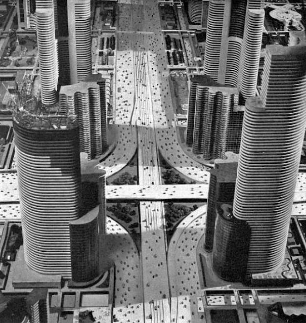 |
| A diorama from the Futurama exhibit at the 1939 World's Fair |
The exhibit was funded by General Motors, of course, because it was largely an advertisement for how amazing life could be if everyone owned a car (or two). It was a compelling vision, however, and one that turned out to be remarkably prescient. After World War II, servicemen returned to a country that was now a world power. They were in search of housing, jobs and a better life, and concepts like Broadacre City and Futurama provided the blueprint for how it should work. Expressways came to life via the federally funded interstate highway system and suburbia took shape through mass-produced housing in places like Levittown outside of New York City. Households steadily became more affluent, automobiles provided increased mobility options, and every level of government spent mightily to build streets and highways to make it all work.
New suburban communities sprang up outside every major city full of new subdivisions, new shopping centers, new schools and new streets. If you couldn’t afford a home in a particular city, simply commute a little further out and the price would drop. Strict zoning regulations (and often racially biased deed restrictions) made suburban locations seem free from the chaos of big city life. If it wasn’t exactly what Broadacre City and Futurama had promised, it was at least reasonably close. What could possibly go wrong?
The ‘Tragedy’ of Induced Demand
Here is where we loop back to our friend William Forster Lloyd and his economic theory about the unfettered use of a finite resource. The entire suburban experiment depends upon a system of streets and highways that can provide free-flowing traffic to a rapidly growing volume of vehicles traveling to and from work, and dozens of other destinations. Initially, it all works reasonably well, but as communities become fully built out the streets get congested and citizens start demanding road improvements. Two-lane streets get widened to four lanes and then six lanes. Highways get rebuilt as expressways with grade separated interchanges, multiple lanes and sometimes multiple levels. With each improvement project promises are made about eliminating congestion and reducing traffic delays, and yet congestion always returns within a few years, often worse than before.
Welcome to what transportation planners now refer to as “induced demand.” When road improvement projects are designed, they are based on careful projections of future demand based on past trends. What is generally ignored (at least until recently) is that road improvements change human behavior which means that past trends are no longer valid. For example:
People who avoided a particular roadway because of congestion will now use that road because of the improvements;
People who drove during non-peak hours because of congestion will now drive during peak hours (or whenever is most convenient);
People who avoided congestion by either not traveling or by using mass transit will now switch to driving on the improved road; and
Developers who had avoided an area because of congestion will now build new projects that increase demand beyond previous projections.
In short, demand appears to blossom out of nowhere and road improvements that were supposed to be effective for a decade or more are clogged within a few short years.
This is the “unfettered access to a finite, valuable resource” in automotive form. Everyone is acting rationally and yet the result is inevitably failure. It is true, of course, that a road which has been expanded can be expanded yet again, But eventually, a limit is reached.
The Katy Freeway (Interstate 10) in Houston is an interesting case study. In 2004, the American Highway Users Alliance (AHUA) called one of the interchanges on the Katy Freeway the 2nd worst bottleneck in the country, supposedly wasting 25 million hours of commuter time each year. In response, the state of Texas spent $2.8 billion to widen 12 miles of the freeway – up to 23 lanes at certain points! Initially, traffic congestion did decline significantly and the AHUA called the project a “success story.” Unfortunately, in the years that followed things got considerably worse, with travel times increasing 30 to 50 percent in just 4 years. [5] According to Google Maps, a 30-mile drive from downtown Houston to suburban Pin Oak Village which takes 32 minutes in free-flowing traffic takes over an hour during the afternoon peak. Capacity has increased, but delay and congestion have gotten worse despite the enormous investment.
Summary – Part 1
It seems that nearly everyone likes to complain about traffic congestion, even in cities where traffic during much of the day is relatively light. As a result, traffic improvement projects are popular and we spend over $120 billion on highway and street construction each year – up from $60 billion just 20 years ago. [6] Arguably, however, we are not getting much bang for our buck. The fact of the matter is that expanding capacity rarely solves the problem of traffic congestion for more than a year or two.
The largest metropolitan areas are the closest to reaching the “finite” part of William Forster Lloyd’s definition which means that they tend to have the most congestion. Lists of the most congested cities in the U.S. typically have Chicago, Boston, New York City, Philadelphia and Miami at the top followed closely by Los Angeles, San Francisco, Washington, Houston and Atlanta. [7] At times, these cities are nearly dysfunctional from a traffic perspective and there are relatively few affordable solutions left to implement from a traffic capacity point-of-view.
What is worse, however, is that traffic congestion is not the only – and perhaps not even the most important – part of the “tragedy of the commons” that I want to discuss. Check back in a couple of weeks for the rest of the story in Part 2 of this post, including some suggestions for what cities should do instead of widening more streets.
Notes:
1. National Traffic and Highway Safety Administration; “Early Estimates of Motor Vehicle Traffic Fatalities and Fatality Rate by Sub-Categories in 2021; U.S. Department of Transportation; May 2022; https://crashstats.nhtsa.dot.gov/Api/Public/ViewPublication/813298
2. Jonathan English; “The Commuting Principle that Shaped Urban History”; Bloomberg CityLab; August 2019; https://www.bloomberg.com/news/features/2019-08-29/the-commuting-principle-that-shaped-urban-history
3. Frank Lloyd Wright Foundation; “Revisiting Frank Lloyd Wright’s Vision for ‘Broadacre City’ “; September 2017; https://franklloydwright.org/revisiting-frank-lloyd-wrights-vision-broadacre-city/
4. Alex Davies; “The World’s Fair Future of 1939 and the Quest for Our Next Utopia”; Wired; December 2017; https://www.wired.com/story/worlds-fair-1939-futurama-utopia/
5. Joe Cortright; “Reducing Congestion: Katy Didn’t”; City Observatory; December, 2015; https://cityobservatory.org/reducing-congestion-katy-didnt/
6. Federal Reserve Bank of St. Louis; “Total Construction Spending: Highway and Street in the United States”; July, 2023; https://fred.stlouisfed.org/series/TLHWYCONS
7. Chris Gilligan; “The 10 U.S. Cities with the Worst Traffic”; U.S. News and World Report; May 2023; https://www.usnews.com/news/cities/articles/10-cities-with-the-worst-traffic-in-the-us