Perhaps “fiasco” is too strong a word – I’ll let you be the judge. After all, the Federal Emergency Management Agency (FEMA) that is responsible for administering the program pays out billions each year in flood insurance claims for tens of thousands of policyholders. After last year’s hurricane Ian, for example, FEMA paid nearly $4 billion in claims ($3.4 billion for structure damage and $445 million for damage to contents) to 48,000 policyholders. Without the federal flood insurance program, the repercussions from Ian would have been far worse and the rebuilding process far slower. [1]
The problem is that the program misleads and underperforms on nearly every dimension of the flood insurance process. It should be so much more than it is. While it would be easy to blame bureaucratic incompetence at FEMA, it would be more accurate to blame the members of Congress who have written the flood insurance laws in such a way as to almost guarantee shortcomings. Unfortunately, neither bureaucrats or politicians are as key to the problem as our own human tendencies to underestimate risk and to make decisions based on personal preferences rather than what is good for our community. There is no simple fix for human stupidity and self-centeredness.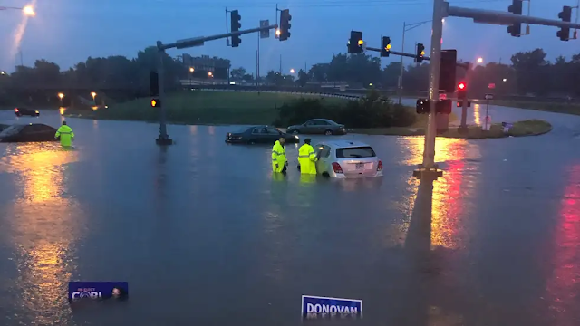 |
| Flooding in St Louis, Missouri, in July of 2022 due to record rainfall. |
We do, however, want the government to bail us out when our poorly thought out decisions lead to disaster. Subsidized flood insurance has been the historic approach, supplemented by grants to local governments to rebuild the supporting infrastructure or funding for the Corps of Engineers to build levees and similar structures to protect our investments.
- Provide information on flood risk for each property so that property owners (and potential owners) can make reasonable investment decisions;
- Provide tools and incentives for cities and counties to monitor flood risk and take appropriate regulatory steps to limit development in areas that are likely to be damaged by future flood events;
- Provide information on how flooding risk is likely to change over time due to changing development patterns, vegetation patterns, weather patterns, and topography; and
- Incorporate all of this information into a rate structure for flood insurance that covers the cost of the program (so that subsidies are not required) and fairly distributes the cost across the policyholders so that high risk properties pay more than low risk properties.
- River-based floods occur when the water level of a river, stream or lake rises above its banks and damages nearby properties. This is typically the result of excessive rainfall or snowmelt upstream of the flood location.
- Flash floods occur when very heavy rains overwhelm the normal provisions for stormwater runoff to the point where water enters buildings that may not be anywhere near a river and have rarely flooded in the past.
- Coastal tidal floods occur primarily during tropical storms when high winds push ocean waters ashore in far greater quantities than normal tidal action (storm surge). However, rising sea levels are causing limited flooding during high or “king” tides even when no storm is present.
Approximately 23,000 cities, counties and other communities participate in the federal flood insurance program covering the vast majority of the country. Within these areas, property owners can purchase federal flood insurance policies through a variety of insurance agencies. In addition, private flood insurance can also be purchased although the cost is usually much higher. Federal flood insurance for residences is typically limited to a maximum of $250,000 of coverage for the structure and $100,000 for contents.
Information on Flood Risk
The first item on my list of flood insurance program goals should be a way for property owners (and potential property owners) to easily determine the likelihood that a particular piece of property will sustain flood damage in the future. FEMA’s approach to this issue is to produce maps that delineate flood risk areas for river and coastal flood events. FEMA refers to these maps as Flood Insurance Rate Maps (FIRM) and they contain shaded areas that have a one percent chance or better of flooding in any given year along with the elevation of the flood waters at various locations. FEMA refers to the shaded area as the Special Flood Hazard Area (SFHA) but virtually everyone else simply calls it the 100-year floodplain (or just floodplain). Historically, the maps were distributed to state and local governments who then made information available to local citizens. Recently, FEMA created a National Flood Hazard Layer viewer which allows anyone to type an address and see its relationship to the floodplain limits.
While this all sounds good, there is in fact a long list of issues with this approach. The first is the unfortunate shorthand name of “100-year floodplain”. This implies that any property in the shaded area on FEMA’s map will flood once every 100 years, which in turn seems like such an unlikely event that it can almost be ignored. This is, of course, a serious misinterpretation of what the map is intended to show. To begin with, a property with a one percent chance of flooding in any given year will average one flood per hundred years if observed over thousands of years, but there is nothing that would prevent that property from flooding two years in a row (or three, or four). In fact, such a property has better than a one-in-four chance of flooding at least once during the term of a 30-year mortgage. That is a bit harder to ignore.
Secondly, only property at the very edge of the floodplain has a one percent chance of flooding. Every property further into the shaded floodplain area has a greater chance for flooding but the map gives no way to determine those increased odds. This is misleading because it encourages people to think of flood risk as binary – either in or out. In reality, the flood risk of a property that is just outside the floodplain boundary is generally just marginally lower than a property which is just inside the boundary, while a property that is well inside the boundary is likely to have a much greater risk. This all gets reduced to “I’m in the floodplain” or “I’m out of the floodplain” which is not a very helpful way for people to think about their flood risk. In my opinion, anyone anywhere near a FEMA floodplain should seriously consider purchasing flood insurance, but that rarely happens.
Third, the depiction of flood risk as having a precise edge is misleading in another, more insidious way. It implies a level of accuracy that simply does not exist. When stormwater engineers try to determine which properties are likely to flood, there are a large number of variables that need to be taken into consideration – how much rain will fall? how intensely will the rain fall? how much rainfall will be absorbed into the ground? which direction will the stormwater runoff flow? how much runoff can be accommodated by the storm sewers? how will different ground surfaces affect the speed of the runoff flow? is land in the area steeply sloped or nearly flat? The list of factors goes on and on. Engineers deal with all of these factors by studying past storm events, plugging numbers into computer models that simplify reality, and making lots of educated guesses.
This educated guesswork means that the floodplain boundary that looks so precise is actually very fuzzy. FEMA knows all of this, of course, but is forced into making a precise line because the law treats property that is in the floodplain very differently from property that is out of the floodplain. If you have a federally backed mortgage, for example, you are required to purchase flood insurance if your property is inside the FEMA floodplain boundary. In addition, if your property is severely damaged in a flood there may be restrictions placed on rebuilding if you are in the floodplain. Properties that are outside the floodplain do not have those requirements.
Finally, FEMA does not even attempt to identify properties at risk from flash floods or floods along very small creeks or tributaries. To do so would make FEMA’s job much more difficult, but it gives property owners and residents a false sense of security. Many properties outside the FEMA floodplain can flood and do flood on a regular basis. The FEMA mapping effort is better than nothing, but far short of what would be ideal.
Active City and County Involvement
City and county governments are in the best position to limit development so that future floods do only limited damage because they are the most involved in regulating where and how buildings get built. FEMA has created a series of development restrictions and floodplain policies that are designed to reduce future flood hazards but it relies upon local government for implementation. Some of these restrictions are mandatory if communities want to be in the flood insurance program, but many are optional. To incentivize greater levels of local government involvement, FEMA has created the Community Rating System. In exchange for implementing optional floodplain management policies, local communities can earn a discount for flood insurance policyholders in their community.
To determine the appropriate degree of discount, each participating community is rated by FEMA on a scale of 1 to 10. A rating of 1 earns discounts of up to 45%, a rating of 5 earns discounts up to 25%, while a rating of 10 earns no discount at all. In theory, the steps taken to implement strict development policies should reduce flood insurance claims and thus the discounts end up being revenue neutral. The odd thing is that many communities that are in the flood insurance program don’t participate in the Community Rating System. For those that do, the majority are rated 7 or worse, and only a small handful are rated better than a 5.
The reality is that implementing strict floodplain regulations is complex and time-consuming. They make an already complicated development process even more complicated. The result is that floodplain regulations often become another bone of contention between the local government and the community. Floodplains are often flat, easily developed parts of the community that are sometimes quite scenic because of their proximity to water. Ruling these areas off limits to development (or imposing expensive conditions) can be seen as unfair to property owners or developers – particularly if the property hasn’t flooded in recent memory. Consequently, many communities participate in the flood insurance program because they want their citizens to have access to flood insurance, but they do just the minimum necessary to keep from being kicked out.
Dynamic Flood Risk
The third item on my list of flood insurance program goals is to provide information on how flood risk is likely to change over time. Earlier in this post I listed a few of the variables that engineers take into account when trying to determine flood risk. All of those variables are dynamic rather than static, and yet FEMA’s approach to flood risk assessment makes virtually no provision for future change. It is a “snapshot in time” view of flood risk.
Consequently, the FEMA flood maps – on top of all the other problems I pointed out earlier – are essentially obsolete almost as soon as they are published. This is particularly problematic since the FEMA maps are rarely updated more than every seven to ten years (if that). The static approach to flood risk coupled with the slow update cycle means that the accuracy of the floodplain boundary is even more suspect than its previously identified weaknesses would have suggested.
As an example, the amount of stormwater runoff during a storm is heavily influenced by whether the land upstream is undeveloped (e.g. used for agriculture) or developed (e.g. used for shops, apartments and office buildings). Runoff from developed land is both greater in volume (since less rain is absorbed by hard surfaces like buildings and parking lots) and runoff speed (since hard surfaces have less friction than open ground covered with plants). The resulting change in flood potential can be significant.
In a growing urban area, a substantial amount of development can take place in a ten-year period of time and most cities routinely project what that is likely to be. Unfortunately, FEMA ignores future development and takes into account only the current land use pattern when developing new floodplain maps. This is a very conservative approach designed to not offend those who want floodplains to be as limited in scope as possible, but it almost guarantees that some development which is initially out of the floodplain will, in fact, flood in the not too distant future.
For a second example, I’m going to venture into the murky arena of climate change. While the vast majority of people now accept that the world climate is changing, predicting how climate change will influence local weather patterns is much less agreed upon and there is considerable debate regarding whether recent weather changes are the result of climate change or just natural variability. One theory that has particular relevance to flood risk is that as the atmosphere warms it will have a greater capacity to store water vapor which means that when severe storms do occur they may lead to more intense rainfall amounts. In a severe storm, both total rainfall amounts and rainfall intensity (e.g. inches per hour) are essential inputs into any flood risk model.
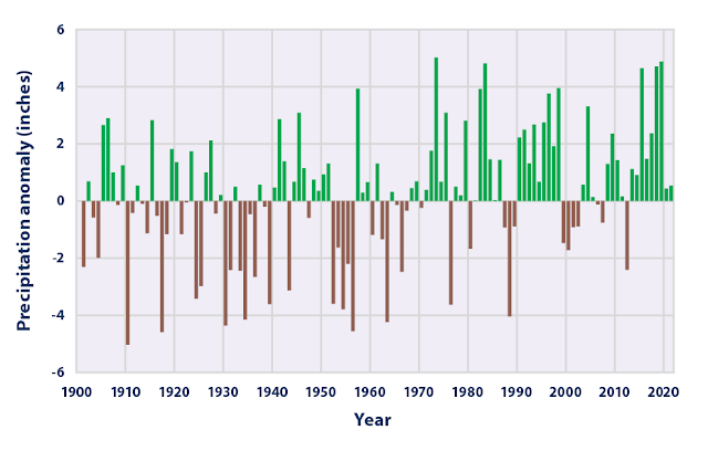 |
| Annual precipitation deviation from the 1901 - 2000 average baseline. Source: NOAA |
This theory is actually backed up by quite a bit of data gathered over a fairly long span of time. As the accompanying chart illustrates, total precipitation has been increasing over most of the United States over the past century. This trend varies somewhat region by region, but the midwest has generally been growing wetter. More importantly, the frequency and intensity of heavy precipitation events has increased more than average precipitation. [4] This is particularly true of the midwest, upper midwest and northeast. As shown in the accompanying maps, this trend is expected to continue in the future.
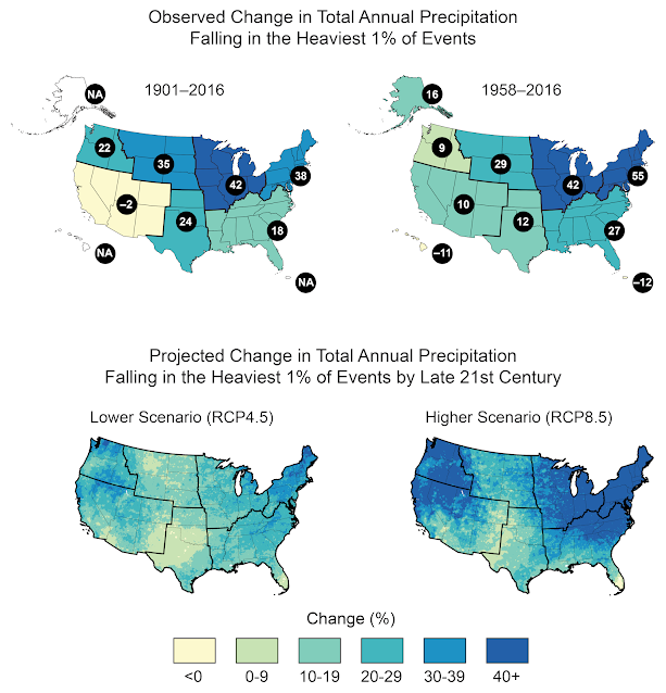 |
| Source: Fourth National Climate Assessment U.S. Global Change Research Program |
This is particularly troubling for flood risk assessment because storms with intense periods of rain are much more likely to produce flooding than storms that produce gentle rains over a long period of time. Most of FEMA’s flood maps were produced based on precipitation statistics created by the National Oceanic and Atmospheric Association (NOAA) and generally referred to as Atlas 14. Like much of the flood risk assessment process, Atlas 14 was backward-looking and explicitly did not take into account the projected effects of climate change. The First Street Foundation, a nonprofit organization focused on assessing climate change risk, estimates that over half of the country’s population live in areas where a 1-in-100 year storm according to NOAA’s Atlas 14 is actually likely to occur every 50 years or less. [5]
I have no way to verify the accuracy of the First Street model, but both NOAA and FEMA have acknowledged the weaknesses of Atlas 14 and NOAA is hard at work on Atlas 15 which will incorporate the increasing frequency of extreme rain events and which will project changes in precipitation into the future taking climate change into consideration. The problem, of course, is that the data from Atlas 15 is just now being made available and isn’t scheduled to be fully released until 2026. Incorporating that data into actual floodplain maps will take years longer.
The Flood Insurance Rate Structure
Private insurance companies price their policies so that they cover the cost of insurance payouts as well as provide a profit for the owners of the company. FEMA, of course, is not expected to turn a profit but unfortunately it hasn’t even been able to cover the cost of insurance claims. Historically, FEMA has focused on affordability and has not used individualized property risk as a basis for the insurance premium. This means that high risk properties were essentially subsidized by low risk properties and the general taxpayer.
As people have built increasingly expensive structures in increasingly risky locations, the cost of paying insurance claims after a natural disaster has skyrocketed. In its early years, FEMA rarely had to borrow from the treasury to cover payouts, but that changed starting in the mid 1990s. By 2006, FEMA owed the treasury over $16 billion. By 2017, the NFIP debt had exceeded $30 billion and Congress canceled $16 billion in debt so that FEMA could pay for the claims from Hurricanes Harvey, Irma and Maria. Borrowing has continued since then, and Congress has finally required FEMA to change its rate structure so that it could cover its costs.
Recently, FEMA rolled out Risk Rating 2.0 – its attempt to make floodplain insurance premiums reflect the actual risk that each policyholder faced. Under the new rate structure, roughly a third of policyholders are already paying for the full risk and some have seen a slight decline in premiums. Slightly over a third of policyholders are facing premium increases between 1 percent and 100 percent. The remaining policyholders will see premiums increase by more than 100 percent – including 9 percent of policyholders that will have premiums increase by more than 300 percent.
Needless to say, some people are not happy about having their subsidy taken away. In fact, 10 states and a variety of local jurisdictions have sued FEMA to block the new rate structure. No doubt the new rate structure will need some tweaking, but I suspect that a return to anything close to previous rates is very unlikely. A recent report from the Government Accountability Office (GAO) generally agreed that the new rate structure was actuarially sound. However, the GAO report noted a significant problem – namely, that the premiums for most policyowners are statutorily capped at a maximum annual increase of 18 percent. The GAO estimated that it would take until 2037 for 95 percent of current policies to reach full risk premiums, creating an estimated $27 billion shortfall. [6]
Summary
Some people have argued that the federal government should get out of the flood insurance business entirely. This is especially true if the full cost of a property’s flood risk cannot be passed on to the property owner (via Risk Rating 2.0 or something similar). After all, if the purpose of government is to protect the safety of its citizens, then promoting risky behavior through subsidized flood insurance makes absolutely no sense.
If there was no federal flood insurance program, then property owners in flood prone areas would have to get insurance in the private marketplace. If they can’t find it, then that is the market’s way of saying that where they live (or work) is too dangerous. If they continue to live in harm’s way, then they should bear the cost of that decision rather than the taxpayer. The fact of the matter is that many people are poor judges of long-term risk and they are equally inept at preparing for the cost of that risk in time to recover when the inevitable disaster occurs. Should the federal government bail them out? I can’t think of a good reason to do so.
Of course, there is no easy way for the government to end a program like federal flood insurance so it is almost inconceivable that it would actually happen. But it makes it all the more crucial that flood risk be made more understandable to the average property owner. The First Street Foundation uses a rating system of 1 to 10 for all properties regardless of their proximity to rivers, lakes or coast lines. That makes a lot more sense than FEMA’s binary “in” or “out” floodplain maps. (Go to https://riskfactor.com/ and type in your address to see it work.)
I also think that communities that participate in the flood insurance program should be on the hook for part of the cost of policy payouts if a disaster occurs in their jurisdiction. That would make cities and counties get serious about enforcing flood risk regulations despite the chorus of protest that would rise from the development community.
So, is “fiasco” the right descriptor for federal flood insurance? I think I have made a pretty good case for “yes” but I’m probably in the minority. We have a soft spot for people in the midst of a disaster and federal flood insurance is one way for us to think we are helping them out. I can’t help thinking, however, that we could do much better.
Notes:
1. “Nearly $4 Billion in Flood Insurance Payments Reach Policyholders After Hurricane Ian”; May 2023; Federal Emergency Management Agency; https://www.fema.gov/press-release/20230504/nearly-4-billion-flood-insurance-payments-reach-policyholders-after
2. Adam Smith; “2021 U.S. billion-dollar weather and climate disasters in historical context”; January 2022; NOAA Climate.gov; https://www.climate.gov/news-features/blogs/beyond-data/2021-us-billion-dollar-weather-and-climate-disasters-historical
3. Roger Yu; “Less than 20% Harvey victims have flood insurance as FEMA braces for tons of claims”; August 2017; USAToday; https://www.usatoday.com/story/money/2017/08/29/insurance-woes-await-flood-victims-under-covered-houston-area/613239001/
4. Katharine Hayhoe, David Easterling, David Fahey, et al; “The Fourth National Climate Assessment; Chapter 2: Our Changing Climate”; 2018; https://nca2018.globalchange.gov/chapter/2/
5. “The 8th National Risk Assessment: The Precipitation Problem”; June 2023; The First Street Foundation; https://report.firststreet.org/
6. “Flood Insurance: FEMA’s New Rate-Setting Methodology Improves Actuarial Soundness but Highlights Need for Broader Program Reform”; July 2023; U.S. Government Accountability Office; https://www.gao.gov/products/gao-23-105977
Special thanks to Tony Meyers, Manager of Engineering Services for the City of Overland Park, Kansas, for his insights into FEMA and floodplain management.